Welcome to the Canadian High Arctic Ionospheric Network (CHAIN)
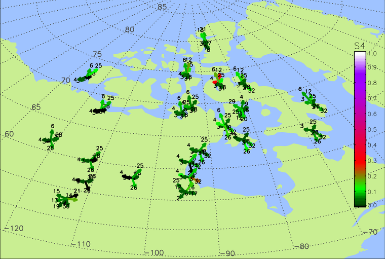
CHAIN Real-time Scintillation Map
The Canadian High Arctic Ionospheric Network (CHAIN) was created in response to the fundamental need for a greater understanding of planetary environments that are affected by short and long term variability of solar output. The Sun-Earth system is a vast coupled system where many physical processes take place, with solar variability driving the terrestrial and space environments. A complete understanding of this complex system requires knowledge about the individual physical processes taking place in the system and in turn necessitates observations. Through the construction and operation of CHAIN, we seek to understand the individual physical processes necessary for the fundamental understanding of the solar-terrestrial coupling and its influence on our planetary environment.
CHAIN is a distributed array of ground-based radio instruments located in the Canadian High Arctic. The CHAIN instruments are 25 high data-rate GNSS Ionospheric Scintillation and Total electron content monitors (GISTM) and 6 Canadian Advanced Digital Ionosondes. Most of these instruments have been sited within the polar cap (a region of open magnetic field lines).
Scientific Objectives of CHAIN
Most of the time, the polar cap ionosphere, a region of open field lines, is directly coupled to the solar wind and interplanetary magnetic field. Mass and energy derived from the interaction are transported across the polar cap and are directly controlled by the variability of solar input (both particle and electromagnetic). Because of this coupling, the polar cap ionosphere is often comprised of ionization and electromagnetic structures. Understanding the polar cap ionosphere will go a long way towards understanding the Solar Wind-Magnetosphere-Ionosphere coupling. The CHAIN scientific objectives are aimed at understanding these polar cap processes. Broad-based scientific objectives of CHAIN are the understanding of:
- Drivers and variabilities of polar cap convection
- Generation and dynamics of ionization structures in the polar cap
- Macroscale – Tongue of ionization (>1000 kms)
- Mesoscale – Polar patches (Few hundred kms)
- Microscale – Scintillation producing structures (Few kms)
- Role of ionosphere in Magnetosphere-Ionosphere (M-I) coupling
- Improve handling/modeling of effects on Global Navigation Satellite Systems (GNSS)
The basic CHAIN measurements, relevant to these scientific objectives, are the 30s resolution measurement of the convection and one minute resolution measurement of the ionograms at the 6 CADI locations, and GNSS-based measurements of TEC and scintillation at 25 stations (50 Hz sampling). One important and unique factor regarding CHAIN is that 6 of the 25 GPS receivers are collocated with ionosondes. This configuration will allow us to perform more realistic 4D (three spatial dimensions plus time) tomographic inversions of the ionosphere using the Multi-Instrument Data Analysis System (MIDAS) for addressing some of the scientific objectives.
CHAIN Project Lead:
Dr Chris Watson - This email address is being protected from spambots. You need JavaScript enabled to view it.